For more than a century, Nepal has looked to its rivers as a path to prosperity. From the 500-kilowatt Pharping plant of 1911 to 4,120 megawatts of installed capacity today, hydropower has become one of the country’s largest areas of domestic investment and an important part of its economic future. Two devastating floods along the Bhote Koshi river system, occurring only fourteen months apart, now raise a question that becomes more important with every new project, whether our understanding of Himalayan rivers has kept pace with the investments we are placing on them.
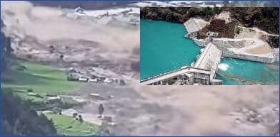
The first warning came on 8 July 2025, when the rapid drainage of a glacial lake in Tibet sent a destructive flood down the Lhende Khola and into the Bhote Koshi. Then, on 26 August 2026, another catastrophic flood descended through the same river system, but its origin was very different. A massive body of glacier ice and rock collapsed roughly 1,200 metres from a high mountain slope, blocked the Lhende Khola and created a temporary dam whose eventual failure released a violent surge of water, sediment and debris downstream through the Bhote Koshi and Trishuli. In little more than a year, the same river system had produced two catastrophic floods through different mechanisms, revealing how varied and difficult to anticipate the hazards developing high in the Himalayas have become.
For generations, Nepalis have been taught that their country possesses the world’s second-largest hydropower potential. The familiar claim does not withstand scrutiny, but the geography that gave rise to it is real. Rivers descending from above 8,000 metres to the plains at around 70 metres within remarkably short distances create exceptional conditions for hydropower and helped sustain the hope that Nepal’s difficult geography could become one of its greatest economic advantages. Yet just as Nepal is finally developing this resource at scale, the mountains, glaciers, snowfall patterns and rivers on which that promise depends are themselves changing.
Nepal’s four great river systems, the Koshi in the east, Gandaki in the centre, Karnali in the west and Mahakali along the far-western border, draw their water from monsoon rainfall, groundwater, seasonal snow and glacier ice in different proportions. Rainfall supplies most annual discharge, while groundwater and snow become particularly important outside the monsoon, with snow acting as a natural reservoir that stores winter precipitation and releases it during spring. That reservoir is becoming less reliable. In 2026, snow persistence across the Hindu Kush Himalaya fell 27.8 percent below the long-term average, the lowest in more than two decades and the fourth consecutive below-normal year. As temperatures rise and snow melts earlier, more water can arrive when it is already abundant while less remains available during the dry months when hydropower production is lowest and electricity is needed most.
This seasonal imbalance matters because Nepal has spent decades building predominantly one kind of electricity system. Most of its installed capacity is run-of-river, producing abundant electricity when rivers are swollen during the monsoon but much less when they retreat in winter. Last winter, generation fell to around 1,600 MW despite installed capacity exceeding 3,800 MW, while Nepal arranged up to 654 MW of electricity imports from India. Meanwhile, the country’s principal seasonal storage system remains the 92 MW Kulekhani I and II complex, whose newer plant was commissioned in 1986. Nepal can therefore have abundant electricity during parts of the wet season while remaining dependent on imports during the dry months.
Glaciers present another layer of risk, and the experience of the Bhote Koshi shows why monitoring glacial lakes alone will no longer be enough. A monitoring system focused on known lakes might have anticipated the July 2025 flood but could have missed the disaster that followed fourteen months later. Unstable mountain slopes and glaciers can also produce rockfalls, ice avalanches, landslides and temporary river blockages capable of sending enormous volumes of water and debris downstream. Nepal must therefore increasingly understand the stability of entire mountain catchments, not simply the condition of individual glacial lakes.
Nowhere are the promise and the risks of this development becoming more concentrated than in the Koshi basin. Roughly 85 hydropower plants already operate there, while 42 of the 47 potentially dangerous glacial lakes identified across Nepal’s Koshi, Gandaki and Karnali basins are also located there. Projects have been developed in cascades along rivers such as the Likhu, Mai and Hewa, while the country’s largest plant, the 456 MW Upper Tamakoshi, lies downstream of Tsho Rolpa, one of Nepal’s best-known potentially dangerous glacial lakes. Nepal undertook one of its earliest major attempts at glacial-lake risk reduction there, but the lake was lowered by only about three metres in 2000 against an original target of up to twenty metres, while its early-warning arrangements have required subsequent rehabilitation and replacement.
Farther east, even larger investments are being made in the Arun basin, where Arun III is under construction and Upper Arun is planned upstream. The Arun begins about 150 kilometres inside Tibet, which means Nepal is placing increasingly valuable infrastructure on a river whose upper reaches it cannot adequately observe from within its own territory. The Bhote Koshi experience demonstrates why upstream information can no longer be regarded simply as a matter of scientific cooperation. For projects involving billions of dollars and decades of expected operation, knowing what is happening upstream is becoming an essential part of national energy security.
The August disaster demonstrated what such geographic concentration can mean in practice. The government’s subsequent assessment recorded 917 employees and workers of affected projects as unaccounted for, while damage and economic losses to the energy sector were estimated at about Rs 151 billion and recovery and reconstruction of the energy and grid system at roughly Rs 390 billion. Although the affected projects had different promoters, lenders and shareholders, they shared the same geographic risk, allowing a single event to impose an extraordinary human and financial cost across several investments at once. Project risk can therefore no longer be assessed only within the boundaries of an individual power plant.
None of this is an argument against hydropower, which remains one of Nepal’s greatest economic assets and will continue to be central to the country’s development. It is an argument for developing it differently as the Himalayan environment changes. Nepal needs to monitor unstable slopes and glaciers as well as glacial lakes, reassess Tsho Rolpa and other high-risk lakes under present conditions, and maintain reliable early-warning systems as permanent infrastructure. Major investments on transboundary Himalayan rivers should be supported by credible systems for obtaining and responding to real-time upstream information, while projects built in cascades should be assessed for their collective exposure rather than individually. Nepal also needs more storage and greater geographic diversification so that the electricity system becomes more resilient to seasonal shortages and catastrophic events.
For decades, Nepal has measured hydropower progress primarily by the number of megawatts installed, but that measure is no longer enough. We also need to ask how much electricity a project will produce in April, what lies fifty or a hundred kilometres upstream, whether several projects could fail in the same event, and whether the river on which today’s financial model depends will behave the same way thirty years from now.
Nepal’s rivers and mountains gave generations of Nepalis the hope that hydropower could help deliver a more prosperous future, and that promise remains. But preserving that promise in a changing Himalaya will require us to measure progress not only by the power we extract from our rivers, but by how wisely we understand, develop and protect the river systems on which that future depends.